
Introduction
Hydrology & Disaster Management (Hyg & DM) division is a specialized division of the Irrigation Department (ID), which is responsible for collecting and maintaining the hydro-meteorological information system of the country. It was formed as a separate division in the year 1935, around 35 years after the formation of the Irrigation Department. However, the collection of hydro-meteorological data in major river basins had been started a few decades back. The river gauge at ‘Nagalagam Street’ in the Kelani River is functioning since 1924. The division mainly collects water levels in rivers and streams. In addition, the rainfall is measured in most of the river gauging stations. As well as wind speed, humidity, temperature, and evaporation are also measured in several stations. There are 42 permanent gauging stations, 66 peripheral stations, and 106 automated stations to be managed by the division. Anyway, there are 56 rainfall and weather stations that are governed by some other parties and the division collects daily data once in six months. At present, the staff consists of a Director of Irrigation, Chief Engineer, Three Irrigation Engineers, One Earth Resources Engineer, Hydrological Data Superintendent (HDS), Hydrological Field Superintendent (HFS), 10 Hydrological Assistants (HA), 28 Hydrological Field Assistants (HFA), Two Draftspersons (DM), One Development Officer (DO), Two Management Assistants (MA), One Stores Assistant, Six Drivers (Including persons who are covering duties of drivers on temporary appointments as drivers), One KKS and 85 Hydrological Survey Helpers (HSH). In addition, there are more than 45 contracts basis laborers are working to cover up the shortages of Hydro Survey Helpers in the Division.
Objectives
The primary objectives of the division, which plays a unique role in ID, are:
- Hydrological Data Collection and Management
- Hydrological Data analysis
- Flood Forecasting and Early Warning
- Coordination with other Disaster Management Authorities for better management of disasters.
Functions
The main functions of the division can be summarized as follows.
- Collection of hydro-meteorological data throughout the country
- Archiving, storing, and dissemination of hydro-meteorological data and information. Processed Hydro-meteorological data and information collected and archived by the division are used not only by the ID, but also by other institutions responsible for water-related infrastructure development for various purposes in the country. These data are mainly used for water resources planning and management for irrigation development, domestic and industrial water uses, flood management, academic research work carried out by different professionals and university students, etc.
- Developing and updating Rating Curves of Hydrological stations around the country (both the permanent and peripheral gauging stations).
- Processing hydro- meteorological data and converting them to useful information
- Developing Rating Curves for irrigation canals.
- Developing flood models for flood early warning and forecasting.
- Mapping flood events in major river basins.
- Publishing Hydrological Annual.
- Monitoring, Forecasting and Issuing flood warnings for major river basins of the country.
Flood Early Warning
Flood monitoring and issuing early warning messages for all major river basins of the country 24X7-hour basis can be considered as one of an important task of the division. These messages are issued to several responsible authorities including Disaster Management Centre (DMC) and the general public in each and every flood event. Historical records bear witnesses how accurately and quickly those messages are being delivered. These immediate actions which were taken by the division have not only reduced damages to the properties but also to save many human lives. Following graphs verify the accuracy and the quickness of the early warning messages which were issued during most recent floods in 2021.
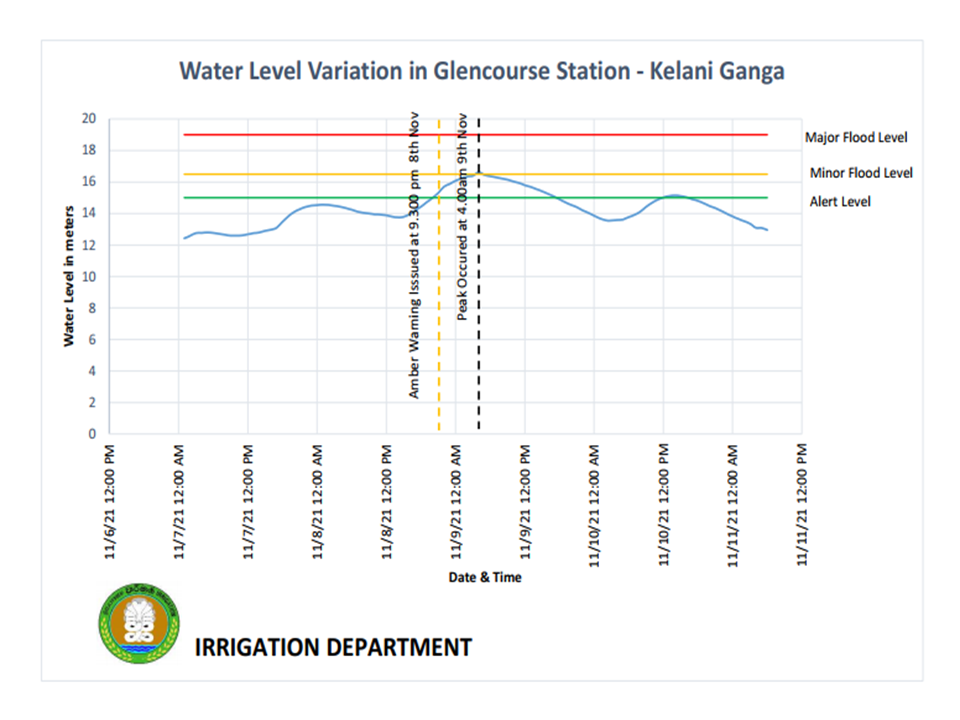
Figure1: Flood Warning Issed for Kelani Basin
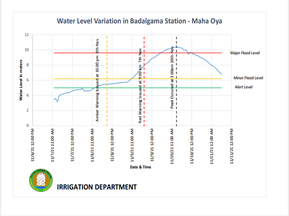
Figure2: Flood Warning Issed for Mahaoya Basin
Preparation of Ratings Curves
Engage in taking discharge measurements can be considered as one of the major key responsibilities of the Division. Discharge Measurements are done not only in Major rivers, but also in tributaries where quantification of water needs to be done. The process of taking discharge measurements is generally known as “current metering”. Developing and updating the Rating Curves are the ultimate purposes of this process. In order to develop an accurate and usable rating curve, these measurements should be taken in different water levels. Measurements during low, normal and flood flows are much essential in developing the curve. These data have been useful in many water resources planning projects.
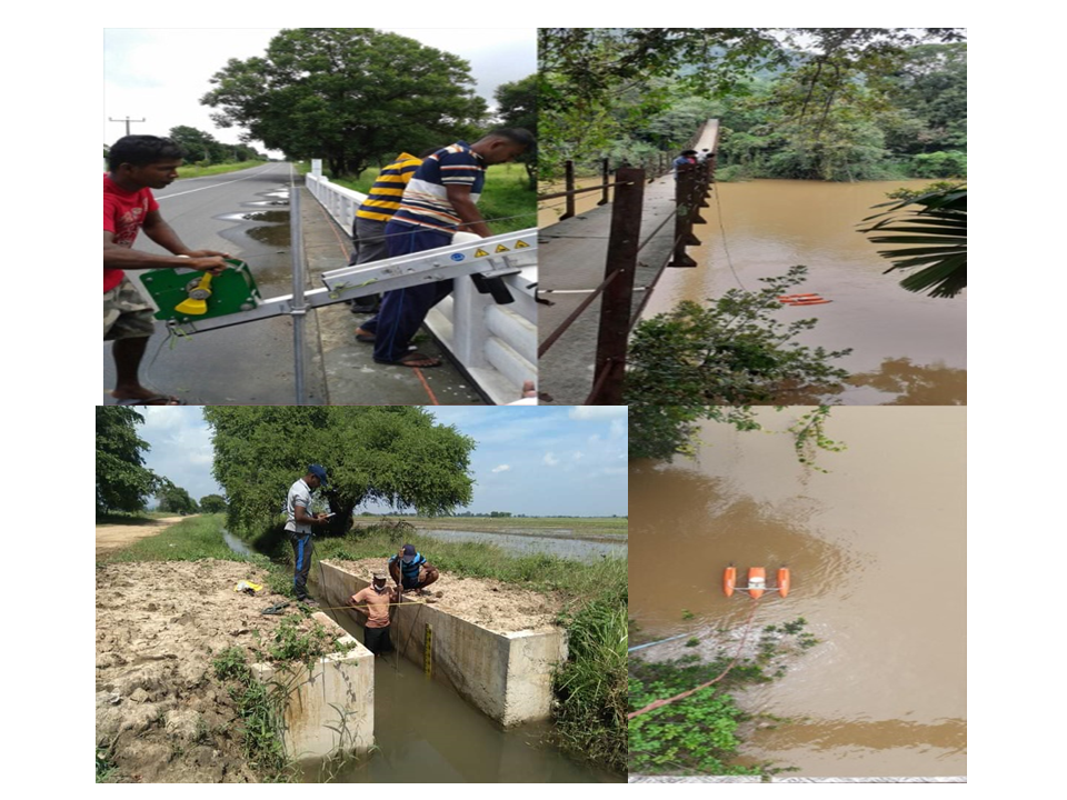
Figure 3: HFAA are Taking Discharge measurements with the assistance of HSHH
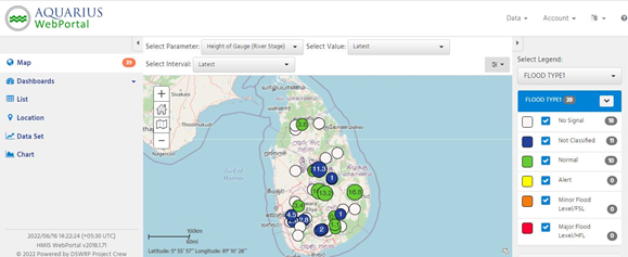
Hydro-Meteorological Information System (HMIS)
In addition to the 42 permanent gauging stations, there are 106 automated stations which are installed, supervised and maintained under this division. Data is transmitted automatically and Engineers and Technical Staff of the division visit those stations regularly in order to maintain the stations and assure the quality of the data. These stations are installed such that it covers most of the critical and important locations of major river systems of the country. Data are transmitted to the system in every 10 minutes. These data play a significant role during flood events and very useful in running hydrological models for forecasting purposes. However, considering the security and the capacity of the system, access to the system is permitted only for authorized parties. The following figure is an image of the user interface where the data is amalgamated and displayed.
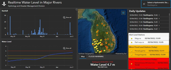
Semi-Automated Information System(SAIS)
As mentioned above, there are 42 permanent gauging stations which collect both river water levels and rainfall hourly. In addition to that some of these stations have been developed in to Hydrometric Weather Stations. These stations are manned with HSHH on 24x7 basis. HFAA are assigned as supervising officers for all these stations and they regularly inspect these stations to maintain the quality of the data. Recently, a semi-automated system has been introduced in order to monitor the water levels of rivers and rainfalls remotely. Public are allowed to access to the dashboard in any moment of the day. The following link can be used to access to the dashboard. https://www.arcgis.com/apps/dashboards/2cffe83c9ff5497d97375498bdf3ff38. Alternatively, it can be accessed by clicking the icon “Real-time Water Levels in Major Rivers” in ID web site main page. The interface of the dashboard is shown in the following figure.
In addition to the above mentioned frequent activities which are undertaken by the Hyg & DM division, the followings are some historical and outstanding workload carried out under the guidance of the Director of Irrigation during the year 2021. Those tasks were successfully completed even facing the COVID 19 pandemic situation in the country.
- Updating Intensity-Duration-Frequency (IDF) Curves for the entire country which is not updated since 1988, under the effort of updating Irrigation Department Technical Guidelines. As the final result, new IDF zones were classified and 11 regions were identified.
- Updating Iso-Yield Curves for the Maha Season (October to March) and for the Yala Season (April to September) respectively.
- Calculating 75% probability rainfall of Agro-ecological zones in Sri Lanka. Since the available has been computed in the early eighties, Hyg & DM division of the Irrigation department updated 75% probability rainfall for 281 stations using the minimum length of 25 years of observed monthly rainfall data and presented.
- Calculating catchment parameters (Cp and Ct) for 15 permanent gauging stations and submitting in order to update Irrigation Department Technical Guidelines.
Contact Details:-
For Hydrological Data inquiries :- This email address is being protected from spambots. You need JavaScript enabled to view it.
For Administration & Tender Purpose :- This email address is being protected from spambots. You need JavaScript enabled to view it.
Head of Section
Director of Irrigation - Hydrology & Disaster Management